 |
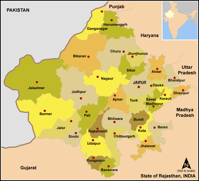
| State Map of Rajasthan |
Rajasthan is bordered by Gujarat to the southwest, Madhya Pradesh to the southeast, Uttar Pradesh and Haryana to the northeast and Punjab to the north. It also shares the India's international border with Pakistan to the west.
Punjab (89 Km)
Bordering Districts: Sri Ganganagar, Hanumangarh.
Haryana (1262 Km)
Bordering Districts: Hanumangarh, Jhunjhunu, Churu, Sikar, Jaipur, Alwar, Bharatpur
Uttar Pradesh (877 Km)
Bordering Districts: Bharatpur, Dholpur
Madhya Pradesh (1600 Km)
Bordering Districts: Dholpur, Karauli, Sawai-Madhopur, Baran, Jhalawar, Kota, Bhilwara, Chittorgarh, Pratapgarh, Banswara
Gujarat (1022 Km)
Bordering Districts: Banswara, Dungarpur, Udaipur, Sirohi, Jalore, Barmer
Pakistan (International Border: Radcliffe line) (1070 Km)
Bordering Districts: Jaisalmer, Barmer
Madhya Pradesh (1600 km) forms the longest inter-state border with Rajasthan. While the shortest inter-state border is formed by Punjab (89 km). Jhalawar district of Rajasthan has the longest inter-state border which shares with Madhya Pradesh. And Barmer district forms the shortest inter-state border which meets Gujarat.
Peripheral Districts of Rajasthan - 25 (Ganganagar, Hanumangarh, Jhunjhunu, Churu, Sikar, Jaipur, Alwar, Bharatpur, Dholpur, Karauli, Sawai-Madhopur, Baran, Jhalawar, Kota, Bhilwara, Chittorgarh, Pratapgarh, Banswara, Dungarpur, Udaipur, Sirohi, Jalore, Barmer, Jaisalmer, Bikaner.)
There are 8 intermediate districts that do not form any boundary with any other state/nation - Pali, Jodhpur, Nagaur, Ajmer, Dausa, Tonk, Bundi, and Rajsamand.
The boundary of Pali district meets a maximum of 8 districts – Ajmer, Rajsamand, Sirohi, Udaipur, Jalore, Barmer, Jodhpur, and Nagaur.
There are 2 such districts of Rajasthan which have an inter-state and international border- Ganganagar (Pakistan and Punjab), and Barmer (Pakistan and Gujarat)
There are 4 districts in Rajasthan that share a border with two other states: Hanumangarh (Punjab and Haryana), Bharatpur (Haryana and Uttar Pradesh), Dholpur (Uttar Pradesh and Madhya Pradesh), and Banswara (Madhya Pradesh and Gujarat).
Also read: India's border with other countries
