 |
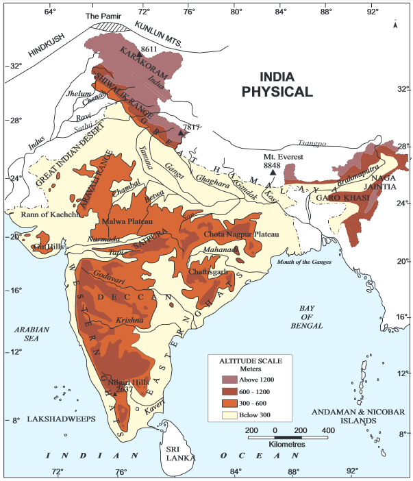
| Geological Structure of India/Source: NCERT |
The Indian Subcontinent was once part of a greater Indo-Australian plate. Over a course of 3-4 million years, the Indian and Australian plates have broken off and have started moving in different directions.
Henceforth, one can say, the present geographical features of the Indian subcontinent are mainly due to the works of endogenic and exogenic forces along with plate tectonics.
On the basis of geological features, India can be divided into 3 geological divisions.
These are
1. The Peninsular Block
2. The Himalayas and other Peninuslar Mountains
3. Indo-Ganga-Brahmaputra Plain.
The Peninsular Block
- It is the oldest and most stable part of the Indian landmass. It is formed by a complex of ancient gneisses and granites. Since the Cambarian period, it has been standing like a rigid block.
- Its northern boundary is marked by an an irregular line running from Kachchh along the western flank of the Aravali Hills and then almost parallel to the Yamuna and the Ganga as far as the Sunderban delta.
- The Karbi Anglong and the Meghalaya Plateau in the northeast along with Rajasthan in the west are extensions of this block.
- In Northeast, it is separated by the Malda fault in West Bengal from the Chotanagpur plateau. Similarly in Rajasthan, the Great Indian desert carpets the block.
- As part of Indo-Australian plate, it has been subjected to various activities. The rift valleys of Narmada, Tapi and Mahanadi along with Satpura Mountains are works of these activities.
- It consists some of the ancient and deteriorating mountain ranges. For example, Aravali Hills, Nallamala Hills, Javadi Hills, Veliconda Hills, Palkonda Hills and Mahendragiri Hills.
The Himalayas and Other Peninsular Mountains.
- The Himalayas along with other Peninsular Mountains are young, weak and flexible in comparision to the Peninsular block.
- These mountains are tectonic in origin, dissected by fast flowing young rivers.
- Some of the main features of this region are gorges, V-shaped valleys, rapids and waterfalls.
Indo-Ganga-Brahmaputra Plain
- This plain is the work of Indus, Ganga and Brahmaputra river.
- Originally, it was geo-synclinical depression which was developed during 3rd phase of Himalayan Mountains around 64 mya.
- The average depth of alluvial deposits in these plains ranges from 1000 to 2000 m.
Source: Class 11 NCERT India: Physical Environment
