 |
| Know Your State: Nagaland |
The state is populated by 16 major tribes. Each tribe has its own unique culture, language and rituals. English is the official language of the state wheareas Nagamese Creole is the unofficial working language of the state
Nagaland is an argarian state and it is known for its rice, corn, millets, pulses, tobacco, oilseeds, sugarcane, potatoes, and fibres. Naga Mircha and Naga Tree Tomato are two agricultural produce which have received GI Tag by WTO.
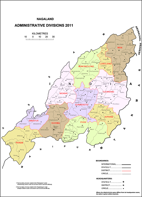
The state is known inter-ethnic conflict since independence of India. The violence and insecurity have stagnated the economic growth of Nagaland. It lies equidistant from the Golden Triangles of Indo-China-Myanmar and Indo-Myanmar-Bangaladesh. Till 1963, it was a union territory and on 1 December 1963, it became 16th state of India. As of now, it has 12 districts with 74 administrative blocks.
Nagaland is a hilly area. More than 78 per cent of Nagaland is covered with forest and known as one of the biodiversity hotspots of the world. Mount Saramati is the highest peak of the Nagaland and its accompanying ranges forms a natural boundary between India and Myanmar.
| Nagaland | State Profile |
|---|---|
| Total Area | 16,579 sq km |
| Latitude | Betweenn 25°6' and 27°4' North |
| Longitude | Between 93°20'E and 95°15' East |
| Date of Formation | 1st December 1963 |
| State Capital | Kohima |
| Commercial Centre | Dimapur |
| Railway Head | Dimapur |
| Airport Head | Dimapur |
| Largest City | Dimapur |
| Largest Village | Kohima Village |
| Population | 19,80,602 Persons (Census 2011) |
| Population Density | 119 per sq km |
| Decadal Population Growth | -0.47% |
| Working Population | 42.74% |
| Sex Ratio | 931 |
| Literacy Rate | 80.11% |
| Male Literacy Rate | 82.75% |
| Female Literacy Rate | 70.01% |
| Official Language | English |
| Loksabha Seats | 1 |
| Rajyasaba Seats | 1 |
| Rainfall | 2000-2500 mm |
| Forest Area | 12966 sq km (78.20) |
| Highest Peak | Saramati 3840 meters |
| Main Rivers | Dhansiri, Doyang, Dhiku, Tizu |
| Districts | 1. Dimarpur, 2. Kiphire, 3. Kohima, 4. Longleng, 5. Mokokchung, 6. Mon, 7. Peren, 8. Pehk, 9. Tuensang, 10. Wokha, 11. Zunheboto and 12. Noklak. |
| Number of Blocks | 74 |
| Seasons | |
| Heavy Rain | May to August |
| Occasional rainfall | September to October |
| Dry Season | November To April |
| State Boundaries | |
| East | Myanmar & Arunachal Pradesh |
| West | Assam |
| North | Assam & Arunachal Pradesh |
| South | Manipur |
| Tribes | Angami, Ao, Chakhesang, Chang, Khiamniungan, Kuki, Konyak, Kachari, Lotha, Phom, Pochury, Rengma, Sumi, Sangtam, Yimchungru, Ziliang. |
| Religions | Christianity (88.1%), Hindu (8.7%), Islam (2.4%), Buddhism (0.3%) and others |
| State Symbols | |
| Animal | Mithun |
| Bird | Blyth's tragopan (Tragopan blythii) |
| Flower | Rhododendron |
| Tree | Alder |
