 |
| Latitudes and Longitudes |
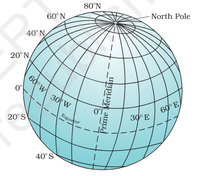
- Globe is the miniature model of Earth. The countries, continents and oceans are shown on the globe on a scaled size.
- An imaginary line about which Earth rotates is known as Axis. It passes through two extreme points: north pole and south pole.
- An imaginary circular line which divides Earth into two halves is known as the Equator. The northern half of the Earth is known as Northern Hemisphere whereas southern half is known as Southern Hemisphere.
Latitudes
- All imaginary circular line from the Equator to each pole is known as parallels of latitudes.
- All parallels in the northern hemisphere are called northern latitudes and parallels in the southern hemisphere are known as southern latitudes.
- Latitudes are measured in degrees. The equator represents the Zero degree whereas each pole represents the 90°. To indicate the hemisphere, latitude degrees is followed by N or S.
- For example, Chandrapur (India) and Belo Horizonte (Brazil) both shares 20° latitude, but they are located in different hemispheres. Chandrapur lies in the northern hemisphere, henceforth, it is represented by 20° N latitude whereas Belo Horizonte (Brazil) which lies in the southern hemisphere is represented by 20° S.
- Tropic of Cancer (23° 26' N), Tropic of Capricorn (23° 26' S), Arctic Circle (66° 33' N) and Antarctic Circle (66° 33' S) are other major parallels of latitude beside the Equator, the North Pole and the South Pole.
- Tropic of Cancer passes passes through Algeria, Niger, Libya, Egypt, Saudi Arabia, UAE, Oman, India, Bangladesh, Myanmar, China, Taiwan, Mexico, Bahamas, Western Sahara, Mauritania, Mali and Algeria are the countries.
- Tropic of Capricorn passes through Namibia, Botswana, South Africa, Mozambique, Madagascar, Australia, Chile, Argentina, Paraguay and Brazil.
- Arctic Circle passes through Norway, Sweden, Finland, Russia, United States, Canada, Greenland and Iceland.
- Antarctic Circle passes through Antartica.
 |
| Heat Zones of Earth |
- The area between Tropic of Cancer and Tropic of Capricorn is known as the Torrid Zone. It receives maximum heat and sunlight throughout the year.
- The area between Tropic of Cancer and Arctic Circle and area between Tropic of Capricorn and Antarctic circle are known as Temperate Zones.
- The area between Arctic Circle and the North Pole and Antarctic Circle and the South Pole is known as Frigid Zone. It is very cold as the Sun doesn't rise above the horizon.
- The mid-day sun never sun shines overhead on any latitude beyond Tropic of Cancer and Tropic of Capricorn. However, it is exactly overhead at least once a year on all latitudes in the torrid zone.
Longitudes
- Longitude is a degree measure of the distance of a point in east or west from an imaginary reference line which runs through the North Pole to the South Pole. These lines of reference are known as meridians of longitude.
- They are semi-circles and the distance between them decreases as these lines approach poles. The distance between them becomes zero at the poles where they meet each other.
- Unlike latitude, all meridians are equal in length.
- The line which passes through British Royal Observatory, Greenwich is known as Prime Meridian. Its value is 0° Latitude. From Prime Meridian, we count 180° eastward and northward.
Longitude and Time
- As Earth rotates west to east, Sun longitudinal position with respect to Earth.
- Each 1° of latitude corresponds to four minutes.
- Each 15° of latitude corresponds to one hour.
- The local time at a standard meridian is taken as the standard time for the whole country. In the case of 82°30' E is taken as the standard meridian.
